The Sacramento region is susceptible to flooding because of its proximity to large rivers and low-lying areas. Flood warnings are made to inform residents of possible threats when there is heavy rain, snowmelt, and increasing water levels.
Flood warnings in the Sacramento area prepare communities by recommending evacuations, closure of roads, and emergency actions. Being informed by local authorities and weather reports is important to provide safety and reduce damage during floods in Sacramento.
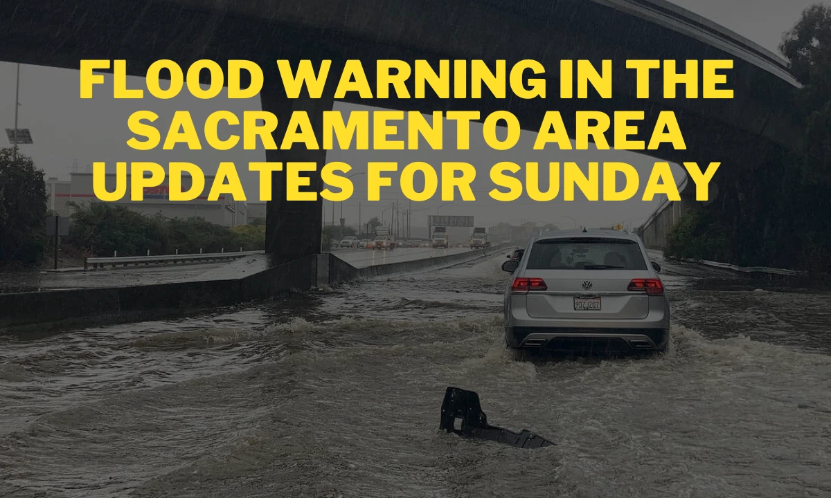
Flood Warning In The Sacramento Area
Parts of the Sacramento River were flowing high Wednesday morning, triggering a flood warning for some Woodland, Davis, and Sacramento International Airport areas. The warning, issued by the National Weather Service, is in effect until 6 a.m. Friday.
There was minor flooding in the Sacramento metropolitan area, with water spilling into a bypass. Following a short lull, rain would resume Wednesday night, possibly worsening conditions. Citizens are instructed to remain vigilant and heed safety alerts.
Where is it flooding in Sacramento?
On Wednesday morning, the Yolo Bypass was inundated at the Lisbon forecast point, west of Sacramento’s Pocket neighborhood. At 10 a.m., the Sacramento River was 19.71 feet at the forecast point, above the 19-foot mark for minor flooding.
The river first went over this level on February 7 and stayed above it, rising to 20.8 feet early Sunday. Predictions suggest water levels will fall below low levels of minor flooding by Thursday afternoon before slightly rising to about 19 feet on Saturday.
Meteorologist Brett Whitin said there is a lag between rain and water level rises at the Yolo Bypass. Even though rain is predicted on Thursday, the Lisbon river stage will not rise until late Friday afternoon. With 19 feet of water, County Roads 107 and 155, and some duck hunting and conservation land flood.
On Wednesday morning, the other sole flooding point on the Sacramento River was Tehama Bridge on Highway 99 East, just north of Chico. The roads south of the Interstate 80 causeway have also been impacted by floodwaters, causing inconvenience to people in the area. It is recommended that residents and tourists stay abreast of weather notices and traffic updates.
What’s in the weather forecast for Sacramento?
The Sacramento region was to experience mostly sunny skies on Wednesday, with a high temperature of 55°F and a low of 48°F. Showers were to start after 10 p.m., with overnight rain totaling three-quarters of an inch and one inch.
- Wind gusts may hit 41 mph, producing potentially dangerous conditions. On Thursday, showers were 80% likely, with a chance of a thunderstorm.
- Rainfall was predicted to amount to half an inch to three-quarters of an inch, and gusts of wind might be up to 39 mph.
- The temperature was forecasted to reach a high of about 60°F, with a low of 49°F at night.
- Thursday evening, rain persisted, adding another tenth to a quarter of an inch of rain with gusts up to 29 mph.
- On Friday, the probability of rain would decrease to 50%, with a high of about 60°F and a low of about 40°F.
- Conditions were to improve as the weekend approached, with skies slowly clearing up, bringing some respite from the wet and windy conditions.
How high is the water in other Sacramento-area rivers?
The Cosumnes River was not flooding Wednesday morning, but predictions showed it would temporarily flow into a levee Thursday and Friday. River levels at the Michigan Bar forecast point near Rancho Murieta were predicted to exceed the 7-foot monitor stage Thursday evening through late Friday, resulting in water flowing into bypasses.
The McConnell forecast point at Elk Grove was also expected to move into the monitor phase early Friday through Saturday morning. In contrast, the American River beneath the H Street Bridge was still several feet below its 42-foot flood level.
Flood Warning In The Sacramento Area: Flood Safty
1. Flood Safety Reminders:
- Do not drive on flooded roads; turn back if you find yourself in one.
- Never drive past barricades or try to wade through floodwaters.
- Make an evacuation plan and have an emergency kit on hand.
2. Emergency Kit Items (according to the City of Sacramento):
- Critical documents (birth certificates, insurance documents).
- Batteries and flashlights.
- Battery-powered radio and extra batteries.
- Prescription medications.
- Food and water supply for a minimum of three days.
- Pet supplies (pet carriers, leashes, and pet food).
FAQs:
Due to the overflowing of rivers in the county’s areas,
The forecast indicates that there will be floods in the area on Wednesday.
Consumers River
Read more articles: